Software Systems

Triggerfish

Triggerfish is a scalable, distributed, navigation, synchronization and management suite specifically designed for marine geophysical survey operations. The system runs on familiar Microsoft Windows platforms and despite comprehensive functionality is simple and intuitive to configure and operate. The system has a proven track record for reliability and has helped clients deliver impressive production statistics. The system interfaces with an extensive range of positioning sensors, recording and source control systems. All common industry formats are supported and new interfaces will be developed on request. For multi-vessel operations, Triggerfish links remote vessels/stations via radio networks. High accuracy, GNSS disciplined, timing components provide source and recorder event triggers and timestamps to microsecond accuracy. The core software components allow support for all types of marine seismic operations, thus making Triggerfish the ideal choice for single, multi-function vessels and flexible crew operations. The software is built on proprietary client/server architecture and can be distributed across a wide-area network – components are available to transfer data via internet to cloud storage or shore facilities.

Major configuration functions are handled by discrete application modules.

Survey Editor

This client application enables configuration of survey parameters. Configurations can be edited off-line or on-line and may be backed-up or restored from file. Geodetic settings are compatible with the OGP/EPSG database and codes - all common projections including polar regions are supported. Coastline, background mapping and obstruction objects can be imported from DXF and Shapefile or created manually. GeoTiff and graphic images are supported. Preplots can be imported\exported from a range of industry standard formats as well as CSV text files. Preplots can also be created interactively on the map. Bathymetry and tide tables can be imported and tide tables are used to correct real-time depth data to vertical datum. The obstruction objects include active zonal alarms linked to the ZIPAS (Zone Incursion and Proximity Alarm System) function.

System Editor

Vessel and towed equipment offsets, sensor interfaces, software and hardware settings are configured in the System Editor application. UKOOA/OGP conventions are observed, resulting in industry-wide compatibility of logged data. Vessel and towed equipment are configured simply and intuitively by "drag-and-drop" in the interactive map. Repetitive steps can be avoided by use of copy-and-paste for objects such as streamers and gun arrays and even sub-components such as streamer groups, birds and air-guns. The System Editor also provides monitoring of interface data and timing status. Automatic back-ups are created every time the System Editor is saved. In multi-vessel systems, access to the System Editor is controlled according to user level assignment in the "User Admin" application.

Survey Manager

The Survey Manager application is used to control the real-time operation and is used to by the operator to set acquisition, deployment or acoustic positioning tasks. The application provides clear steering and status information. For multi-vessel operations the master system can monitor all crew activities. For dual shooting vessel and undershoot operations steering displays are available to guide vessels in maintain in-line separation. If interfaced, AIS and radar targets can be monitored on the map and interactive table. Multiple instances of the application can be running.

Navigation Monitor

The Navigation Monitor client application provides a comprehensive real-time QC and reporting package. Real-time QC displays are available to monitor all raw interface data and computed metrics. Data can be monitored in shot and time domains and during on-line or off-line vessel status. The system operates in on-line mode, directly connected to the Triggerfish server or off-line reading data from XML log files. Comprehensive maths functions are provided to manipulate data items. Data can be exported in customisable text (CSV) files and data can be reported as exceptions to user defined criteria. Reports are conveniently scaled to fit standard paper sizes.


Attribute Mapper

Attrimap

Attrimap provides a spacial mapping tool for displaying survey attributes. Filters and threshold criteria can be applied to highlight data items of interest. Filters can be grouped and cascaded. Typical attributes include waterdepth, line relative metrics such as distance offline and line status values.


Processing and QC Software

GeoMetis Shotpoint

Geometis Shotpoint - a software tool for quality control analysis and data processing of positioning data on Towed Streamer and OBS or TZ seismic surveys. Using an interactive control system the user can define and step through a host of data analysis and reprocessing modules depending on the client requirements. Geometis Shotpoint, provides a series of tools to assess data quality prior to reprocessing so the actual recorded data is analysed.

  • Providing a lightweight and portable system with a small physical footprint.
  • Software is intuitive, easy to learn and use and provides rapid data analysis.
  • Convenient Web based access and email support.
  • Interactive multi-screen processing for flexibility and user control.
  • Data format checking and verification (SPS and UKOOA/OGP P2/P1format).
  • Receiver Positioning (First Breaks and acoustics).
  • Statistical, graphical and textual displays.
  • User defined process/QC reporting.
  • Easily check SPS files for compliance.
  • Analysis of SPS data.
  • Graphical and text displays.
  • Software is installed and configured by the user and runs on notebook or desktop computers.
  • Runs on all Microsoft Windows platforms.

  • Shotpoint is owned and distributed by NorthStar Geo Limited. InProspect have an agreement to act as a sale and rental agent on their behalf.

    Binning and coverage analysis

    Coverpoint

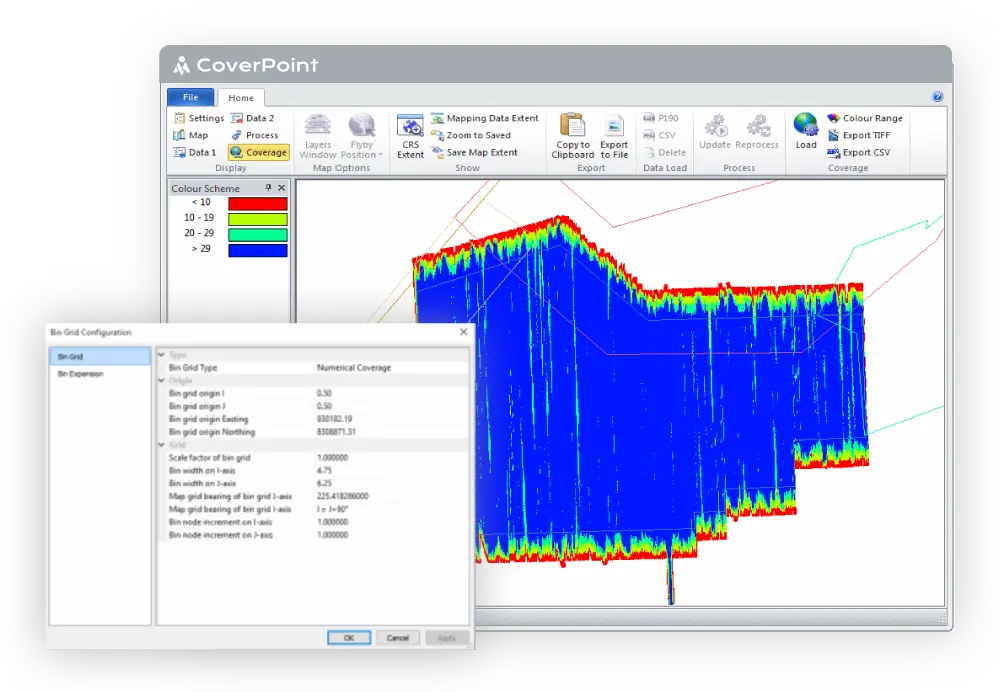
    CoverPoint is an advanced system for analysing marine survey coverage. Data Entry is designed to be simple and efficient. Entered Data is shown on a map to aid the setup process, and the system also allows for the mapping of navigation data to aid data analysis. The CoverPoint software can bin data using full offset and azimuth-based fold generation, or by a simpler hits-per-bin coverage computation. Coverage can be generated from two distinct sets of data and compared against each other. Data can be colour coded and presented in a number of ways to aid viewing. The resulting coverage data can be exported as a geo-referenced image file for use in GIS systems. Coverpoint is fully integrated with Triggerfish software.

  • Coverage and binning of marine surveys.
  • Easy to setup, configure and use.
  • Graphical displays to aid configuration and setup.
  • Generation of reports and GIS outputs.
  • Powerful information displays.

  • CoverPoint is owned and distributed by Mid Point Geo Limited. InProspect have an agreement to act as a sale and rental agent on their behalf.

    Hardware Systems

    Timing Systems

    The Timing Interface Unit (TIU) and TSYNC PCIe card were introduced in 2018 and replace the legacy GTU (Gravel Trigger Unit). The system consists of a PCIe interface board that is installed in the Triggerfish server PC and the TIU, 1U enclosure, which contains opto-isolator circuits, voltage selection and switching for high-low impedance outputs - high impedance outputs are designed for direct connection to seismic recorder auxilliary channels. Multiple units can be installed to increase the number of triggers available. All timing functions are retained within the TSYNC system and events are requested via the timing card API. This ensures that timestamping and events are controlled not within software loops in the Triggerfish code but at the hardware level within the timing card itself, this removes ambiguity associated with systems which use 1PPS epoch within application software.

  • 1U rack-mount enclosure + PCIe card.
  • GNSS disciplined OCXO or TCXO options available.
  • 4 Output triggers, microsecond accuracy, high/low impedance, 1.2V/5V/12V.
  • 4 Input triggers, 3V-12V, timestamping to microsecond precision.
  • 1PPS & IRIG outputs.
  • UTC, IAT or GPS time references supported.
  • Multi-vessel synchronisation radio TDM (time division multiplex) control.


  • Computer Systems

    InProspect can supply custom computer hardware and serial and network server devices to run Triggerfish systems. All form-factors - rackmount (1U and upwards), desktop and laptop computers can be delivered. By convention Windows 10 Enterprise OS (IOT) edition is installed. This OS is a light-weight version of Windows ideally suited to industrial "always-on" applications.


    Radio Systems

    InProspect can supply and advise on a range of radio products to suit specific operational needs and comply with local regulations. Where necessary, signal boosters, antenna towers/masts and specialist antennae can be provided. InProspect are able to provide radio transmission path analysis to assist in system design.


    Serial, UHF radio, Trio ER450

    Used for exclusive synchronization radio link. The shot radio system carries only timing and shot header data. This robust, serial data link ensures reliable shooting and synchronization for remote recorder crews. Ranges in excess of 25Km are achieved using these radios.

    Network, 900Mhz radio, Trio JR900

    The 900Mhz Trio JR900 network radio provides high speed data transfer at long ranges. These radios are used in the Triggerfish "Data Radio" communications system that transfers all non-time-critical information between vessels. The data radio network supports remote configuration, transfer of vessel, source and receiver positions, acoustic asset IDs and may also be used to re-broadcast RTCM correction data. Amplifiers are available with these radios if required.

    Network/Serial, UHF radio, Aprisa SR+

    The Aprisa SR+ radio combines the functions of serial and network data links. Advanced signal processing techniques allow the unit to provide high capacity network communications on UHF frequencies and simultaneously (with priority) pass serial traffic on a dedicated serial link.

    Mast-mount radio box enclosures

    Rugged, weatherproof (IP67) enclosures can be supplied with radios fitted. These units can be mounted externally, close the antenna and thereby reduce issues caused by RF signal loss on long coax runs.